Biljni svijet
Bogatstvo biljnog svijeta očituje se u popisu od do sada gotovo 1000 zabilježenih biljnih vrsta i podvrsta, od čega je 79 endemičnih. Većina od zabilježenih endema je raširena po cijelom Velebitu, a samo stenoendem, okruglolisna pjeskarica (Arenaria orbicularis) raste u kanjonima Velike i Male Paklenice, te je u novie vrijeme zabilježen kod Vrlike, u dolini rijeke Cetine. Velika raznolikost, prisustvo reliktnih, endemičnih, rijetkih i ugroženih, zakonom zaštićenih vrsta, od kojih se neke vrste nalaze u Crvenoj knjizi biljnih vrsta RH, svrstava Park u floristički izuzetno vrijedno područje ne samo u Hrvatskoj nego u Europi i u svijetu. U flori Parka prevladavaju sljedeće porodice: glavočike (Asteraceae) i (Cichoriaceae), trave (Poaceae), lepirnjače (Fabaceae), usnače (Lamiaceae), ružovke (Rosaceae) i karanfili (Caryophyllaceae).
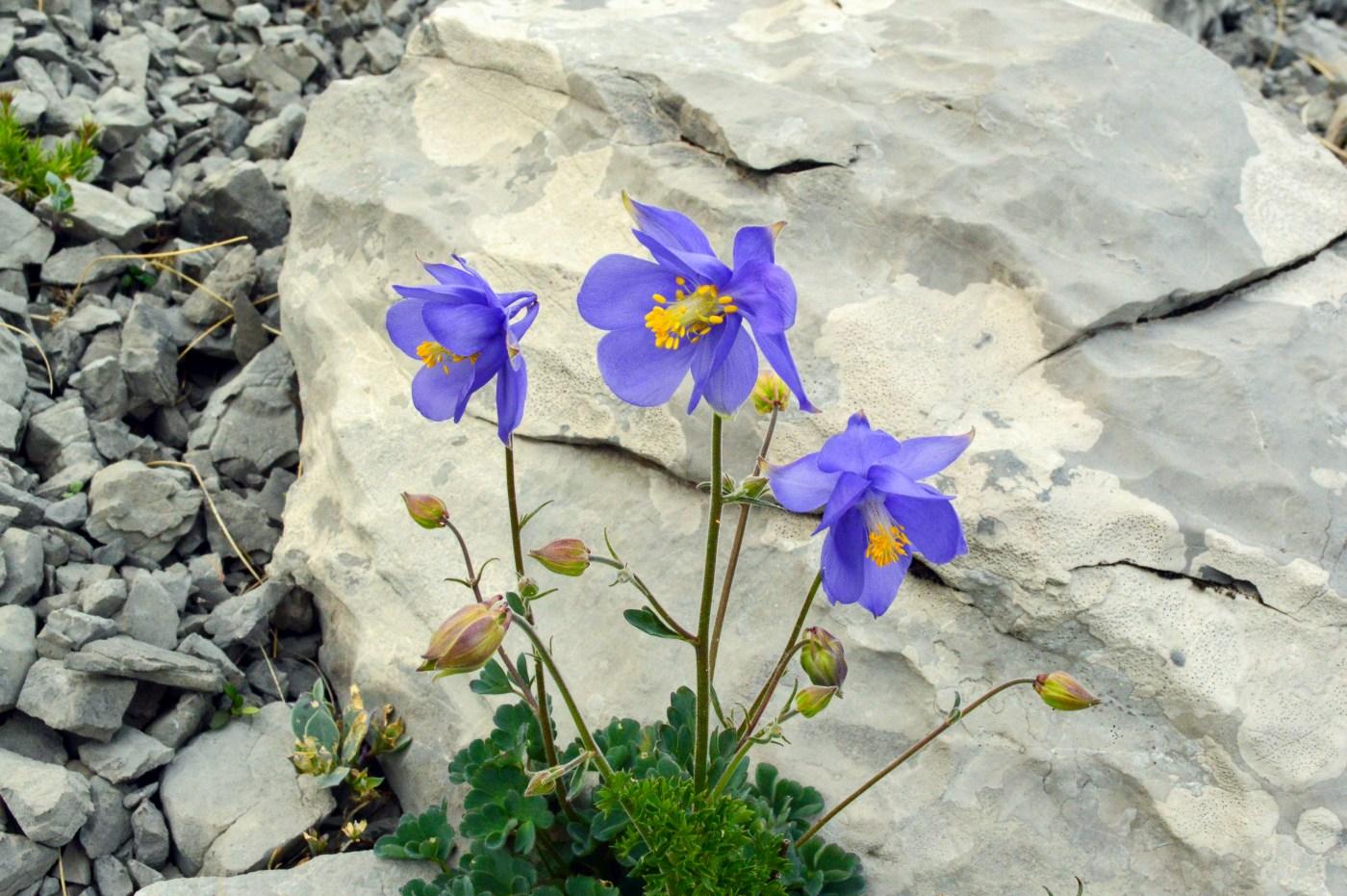
Trošenjem i lomljenjem stijena pod utjecajem sunca, leda, vode i temperature, ispod strmih grebena i vrhova, kakvi su primjerice Buljma ili Vaganski vrh, razvijaju se točila ili sipari. Na ovakvim krškim staništima može se održati samo mali broj vrsta jer je podloga rahla, pomična, a lomljeno stijenje različite veličine. Na točilima rastu mnoge endemične biljke kao što su kitajbelov pakujac (Aquilegia kitaibelii), malijevo devesilje (Seseli malyi), tercijarni relikt lanilist (Linaria alpina) i široko rasprostranjena šuškavica (Paronychia kapela).
Pukotine stijena imaju specifične mikroklimatske uvjete koji su mnogim biljkama omogućili da prežive nepovoljno razdoblje posljednje oledbe. Zbog toga na ovakvim krškim staništima nalazimo veliki broj endemičnih i reliktnih vrsta. Neke od njih su prozorski zvončić (Campanula fenestrellata), hrvatski zvončić (Campanula cochlearifolia) i valdštajnov zvončić (Campanula waldsteiniana).
Kamenjari i stijene obrasli su rijetkim i ugroženim vrstama poput tulipana (Tulipa sylvestris), planinskog likovca (Daphne alpina), gromotulja (Globularia cordiifolia), krkavine (Rhamnus intermedia) i presličice (Muscari botryoides).
U dolcima gdje se dugo zadržava snijeg razvijaju se zajednice koje po bogatstvu vrsta i šarenilu cvijeća čine najljepše biljne formacije Nacionalnog parka Paklenica. Ondje su osobito brojni narančasti i žuti kranjski ljiljani (Lilium carniolicum), majčina dušica (Thymus sp.), veliki lisjak (Astrantia major), mahunka (Biscutella laevigata) i crveni uskolisni likovac (Daphne cneorum). U nižim dijelovima, Parka na Velikim i Malim Močilima, nalaze se vlažne livade i obradive površine koje su u proljeće bogate orhidejama. Kao raritet ističemo gospinu papučicu, fanglu (Cypripedium calceolus), jednu od najljepših europskih orhideja, koja je zabilježena na nekoliko lokalieta ličke padine uz rub bukovih šuma.
Šume
Fenomen šuma je jedan od glavnih razloga zbog kojeg je prostor južnog Velebita proglašen nacionalnim parkom. Danas u Parku obitavaju šume stare iznad 300 godina, a procjenjuje se da pripadaju među najstarije sastojine u Sredozemlju. Zbog toga su dvije komponente bukovih šuma, dana 07.07. 2017. god. na zasjedanju UNESCO-ovog Odbora za svjetsku baštinu u Krakowu, svrstane na Popis svjetske baštine UNESCO-a. Tako su bukove šume u predjelu Oglavinovac-Javornik i u predjelu Suva draga-Klimenta posebno uključena na svjetsku listu prirodne baštine. Isto vrijedi i za bukove šume Hajdučkih i Rožanskih kukova koje su u NP Sjeverni Velebit svrstane na listu svjetske baštine u programu „Bukove prašume i izvorne bukove šume Karpata i drugih regija Europe“.
Na najnižim dijelovima uz morsku obalu razvijaju se zajednice mješovitih šuma medunca i bjelograba (Querco-Carpinetum orientalis- croaticum). Dio šuma je posječen pa se razvila degradacijska zajednica dračika (Paliuretunm adriaticum). Iznad ove zajednice raširene su šume crnog graba s jesenskom šašikom (Seslerio-Ostryetum), razvijene na nadmorskim visinama od 650 do 900 m, posebno na primorskim padinama pod utjecajem mediteranske klime. Na ove sastojine se u visinskom smjeru nastavljaju primorske šume bukve s jesenskom šašikom (Seslerio-Fagetum sylvaticae). Te šume nastanjuju različite raspone nadmorskih visina od 300 – 900 m i najzastupljenije su bukove zajednice Paklenice. Na ekstremno plitkim i skeletnim, suhim tlima istaknutih grebena i glavica centralnog dijela Parka razvija se zajednica šume crnog bora s dunjaricom (Cotoneastro-Pinetum nigrae). Prirodno se razvija na grebenima i strmim padinama na visini od 400 – 1200 m. Pretplaninske bukove šume s urezicom (Polystycho lonchytis-Fagetum) čine gornju granicu šumske vegetacije u visinskoj zoni 1000 - 1450 m. Zbog duljeg zadržavanja snijega, debla su u donjem dijelu povijena, čvornata i često neobičnog oblika. U svom najgornjem dijelu ova zajednica čini klekovinu bukve. Bukove šume s bekicom (Luzulo-Fagetum) rastu na kiseloj podlozi trijaskih klastita. U njima nema grmlja već je na tlu sloj mahovina radi čega djeluju prozračno, a mahovina osigurava vlagu bogatoj fauni tla. U blizini vodotoka razvijena je brdska šuma bukve s velikom mrtvom koprivom (Lamio orvalae-Fagetum). Klekovina bora krivulja s kozokrvinom (Lonicero borbasianae-Pinetum mugi) zauzima vršni pojas Velebita. To je najveća i najkompaktnija površina pod klekovinom bora u cijeloj Hrvatskoj.
Životinjski svijet
Raznolika staništa na prostoru Paklenice kao i visinska raslojenost, pružaju dom raznolikoj fauni.
Beskralješnjaci
O beskralješnjacima na području parka ima relativno malo podataka. Ispod kamenja brojni su i štipavci (Scorpiones). Svi su štipavci predatori i na kraju tijela imaju bodlju koja je spojena s otrovnom žlijezdom. Otrovom omamljuju ili ubijaju plijen. Vrste koje žive u Nacionalnom parku također su otrovne, ali nisu smrtno opasne za čovjeka. Među otrovne vrste paučnjaka u Parku, ubrajamo i sve paukove (Aranea). Najveća vrsta koju se ljeti može vidjeti na velikim mrežama koje gradi između grmlja je pauk krstaš (Araneus diadematus). Zasigurno među najljepšim paucima je jedna malena vrsta koju se najlakše može uočiti po crvenoj boji zatka. To je pauk skakač (Eresus) koji živi na stijenama i pokreće se brzim skakanjem s jedne na drugu stranu. Osim brojnih vrsta za ljude potpuno bezopasnih paukova različitih kriptičkih boja koje im pomažu da ostanu sakriveni među travom i cvijećem i love kukce, u Parku ili u njegovoj najbližoj okolici žive i vrste čiji ubod može biti opasan za ljude. To su crna udovica (Latrodectus mactans) zabilježena u Marasovićima i tarantula (Lycosa sp.). Obje vrste se zadržavaju na tlu ispod kamenja i u šupljinama. Grade guste pridnene mreže. Tarantula se dugo brine za leglo, a mlade paučiće nosi na leđima dok ne ojačaju.
Jedan od najvećih razreda životinjskog carstva s oko 30 redova su kukci. Ovi člankonošci, s tri para nogu, su svakako najveća, ali i slabije poznata skupina životinja u Parku. Pretpostavlja se da prostor Parka nastanjuje oko 2500 različitih vrsta.
Većina poznatih vrsta beskralješnjaka pripada skupinama koje su atraktivne za posjetitelje, poput leptira. Iako je fauna dnevnih leptira istraživana, noćni leptiri su gotovo nepoznati. Među njima se najlakše uočava najveća vrsta leptira u hrvatskoj fauni – veliko noćno paunče (Saturnia pyri). Od dnevnih leptira, a zabilježene su 84 vrste na području Parka, najbrojniji su predstavnici porodice plavaca (Lycaenidae). Najveći danji leptiri su prugasto jedarce (Iphiclides podalirius) i lastin rep (Papilio machaon). Visokoplaninske livade nastanjuje i jedan od najljepših hrvatskih leptira, apolon (Parnassius apolo).
Osim leptira na livadama su česti bumbari koji oprašuju osobito biljke iz porodice usnača (Lamiaceae), divlje i pitome pčele, ose i skakavci. Divlje pčele grade pčelinjake u dupljama šumskog drveća, a ose grade manje osinjake uglavnom ispod kamena ili u pukotinama stijena. Različite vrste skakavaca su teritorijalne. Svoje područje označavaju intenzivnim glasanjem koje proizvode tako što trljajaju krila o noge ili krila o krila. Slične skakavcima bojom i veličinom su bogomoljke. No, za razliku od skakavaca koji se hrane biljem one su mesojedi. Skrivaju se u gustoj vegetaciji, a prednje noge drže uvijek spremne za hvatanje plijena. Jaja ostavljaju u gnijezdima od pjene koja se skrutne na zraku, a zalijepe ih za kamen. Još jedan opasan predator koji se hrani kukcima često se može vidjeti u grmlju na rubovima livada. To je grabežljiva stjenica iz roda Harpactor. Intenzivne je crvene boje, a na glavi ima dugu bodlju kojom isisava žrtve. U šumama su brojni mravi, od kojih je šumski mrav (Formica rufa) kao biološki značajna i rijetka vrsta šuma zakonom zaštićena u cijeloj Hrvatskoj.
Jedan od najvećih redova kukaca su kornjaši (Coleoptera). Međusobno se razlikuju bojom, oblikom, veličinom te mjestom i načinom života. Iako brojne vrste zbog skrivenog života ili male veličine ne primjećujemo, drugi su veliki i lako uočljivi te se s njima u prirodi često susrećemo. Najčešće dolaze pojedinačno, no u doba parenja ili hranjenja mogu se vidjeti u velikim skupinama.
Među kornjašima nalazimo brojne česte vrste poput hrušta (Mellolontha mellolontha) ili ružičara (Oxythrirea funesta), ali i brojne rijetke vrste kao što su alpska strizibuba (Rosalia alpina). Ova je vrsta u većini europskih zemalja jako prorijeđena te se nalazi na brojnim crvenim listama ugroženih vrsta. Kao ličinka provodi život u deblima starih bukava kojih je u šumi sve manje. U Paklenici se ova vrsta može vidjeti relativno često. Još su neke vrste strizibuba Paklenice ovisne o starim šumama jer se ličinke hrane drvetom te ih se može vidjeti u području gdje su u blizini gusti sklopovi šuma. Najveće od njih su hrastova strizibuba (Cerambyx cerdo) i strizibuba (Morimus funereus). U šumama se nalaze i druge velike vrste kornjaša poput jelenka (Lucanus cervus) i nosorošca (Oryctes nasicornis).
Najprimitivniji predstavnici kornjaša su trčci (Carabidae). Ime su dobili po načinu kretanja – trčanjem po tlu, premda su pojedine vrste dobri letači. Prema načinu ishrane većinom su mesojedi, samo je manji broj vrsta biljojeda. Uglavnom su aktivni noću kada traže hranu, no za vlažna i oblačna vremena, te u rano proljeće sreću se i tijekom dana. S obzirom da su vrlo osjetljivi na promjene u ekosustavu, mogu biti odlični bioindikatori staništa koje nastanjuju, posebno šumskih. Najveći trčak je Proceras gigas, duljine 7 cm, a zabilježen je oko planinarskog doma u Paklenici u zoni bukovih šuma. U europskim zemljama postaje sve rjeđi pa je i zaštićen. Iz roda Carabus, u NP Paklenica su zabilježene 4 vrste: C. violaceus, C. caelatus, C. catenulatus i C. intricatus. Zanimljive su i dvije vrste iz roda Calosoma, C. inquistor i C. sycophanta. Hrane se gusjenicama, a aktivne su danju. Od endemičnih vrsta Balkanskog poluotoka treba spomenuti dvije vrste Myas chalybaeus, i Laemostenus dalmatinus.
Na stazama i putovima, posebno tamo gdje se još može vidjeti stoka, česti su kotrljani. Ove vrste uzimaju komadiće izmeta (balege) te ih kotrljaju oblikujući kuglu koju zakapaju u zemlju. U kuglu odlože jaje iz kojeg se razvija ličinka koja se hrani balegom dok ne odraste.
Kralješnjaci
Od kralješnjaka poznate su skupina vodozemaca i gmazova, a zabilježene su s 31 vrstom. Vodozemci su zastupljeni sa 6 vrsta, a gmazovi s 25 vrsta. Gmazovi su brojem vrsta i jedinki brojniji od vodozemaca jer preferiraju suha staništa. Najčešće se mogu vidjeti na stijenama izloženim suncu, uz šumske rubove i putove. Ove hladnokrvne životinje reguliraju tjelesnu temperaturu tako što se određeno vrijeme sunčaju, a u jutro i za hladnih dana su sporiji pa ih se može lakše promatrati. Zabilježeno je 13 vrsta guštera, 11 vrsta zmija i jedna vrsta kopnenih kornjača. Od zmija samo dvije su otrovnice opasne za čovjeka i to poskok i planinski žutokrug.
Među zmijama je utvrđeno 11 vrsta. Najčešće se u Parku mogu vidjeti neotrovnice šara poljarica (Hierophis gemonensis), pjegava crvenkrpica (Zamenis situla), bjelica (Zamenis longissimus). Poskok (Vipera ammodytes) i vrlo rijetki planinski žutokrug (Vipera ursinii subsp. macrops) jedine su otrovnice na ovom području. Poluotrovnice su crna krpa (Telescopus fallax) i zmajur (Malpolon insignitus).
Ptice su najbrojnija skupina kralješnjaka, a do sada su zabilježenih 260 vrsta, od toga 167 vrsta unutar granica nacionalnog parka. Ptičji svijet je zastupljen sa 111 vrsta gnjezdarica, i to na širem prostoru Parka. Od gnjezdarica treba spomenuti zajednicu ptica stijena i litica u kanjonima Velike i Male Paklenice s 24 ptičje vrste. Najčešći su brgljez kamenjar (Sitta neumayer), modrokos (Monticola solitarius), bijela čiopa (Tachymarptus melba), hridna lastavica (Ptyonoprogne rupestris) i divlji golub (Columba livia).
Posebnu vrijednost Parku daju ugrožene i rijetke vrste ptica grabljivica kao suri orao (Aquila chrysaetos), sivi sokol (Falco peregrinus), orao zmijar (Circaetus gallicus) i jastreb (Accipiter gentilis). Od sova, u Parku je zabilježeno sedam vrsta. Najbrojnija je šumska sova (Strix aluco) i ćuk (Otus scops), a u kanjonu Velike i Male Paklenice se redovito gnijezdi najveća europska sova, ušara (Bubo bubo).
Monitoring ptica grabljivica pokazuje da se na širem području nacionalnog parka gnijezde 3 para sivih sokolova (Falco peregrinus), 3 para orla zmijara (Circaetus gallicus), te 1-2 para eje livadarke (Circus pygargus). Sve tri vrste ukazuju na važnost i očuvanost krških staništa na području nacionalnog parka Paklenica. Zadržavanje 1-2 para ušara (Bubo bubo) u penjačkoj zoni, među alpinističkim smjerovima pokazuje da još uvijek postoje niše u kanjonu Velike Paklenice pogodne za gniježđenje ove najveće europske sove.
Šumske sastojine bogate su djetlićima od kojih su najrjeđi planinski djetlić (Dendrocopos leucotos) i crvenoglavi djetlić (D. medius). Najčešće i najbrojnije vrste su veliki (D. major) i mali djetlić (D. minor), kao i siva (Picus canus) i crna žuna (Dryocopus martius).
Bjeloglavi sup (Gyps fulvus) je do konca 1999. godine bio zastupljen s tri para. Na žalost, opadanje broja stoke u Velebitu i sve češća trovanja grabežljivaca, osobito vuka, pridonijele su njegovom izumiranju s prostora Parka. Crkavica (Neophron percnopterus) je iz Hrvatske nestala još 1987. god., a zadnji puta je promatrana u kanjonima Velike i Male Paklenice. Danas bjeloglavi sup povremeno prelijeće iznad južnog Velebita u potrazi za hranom ili u vrijeme jesenske selidbe, kada mlade ptice lete duž istočne obale Jadrana prema Africi.
U skupini sisavaca zabilježene su 53 vrste. Od velikih vrsta na prostoru Parka može se sresti srna (Capreolus capreolus), jelen (Cervus elaphus), divokoza (Rupicapra rupicapra) i divlja svinja (Sus scrofa). Od zvijeri, na prostoru Parka obitava smeđi medvjed (Ursus arctos), vuk (Canis lupus), lisica (Vulpes vulpes), divlja mačka (Felis sylvestris) i povremeno ris (Lynx lynx),
PTICE GRABLJIVICE
SOVE
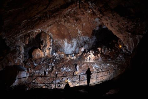
Živi svijet podzemlja
Podzemlje je specifično stanište u kojem mogu preživjeti samo posebno prilagođene vrste. U podzemlju nema autotrofnih organizama (biljaka), pa su skraćeni hranidbeni lanci. Zbog toga u spiljama izostaje skupina životinja koje se hrane biljkama. Organska tvar potrebna za održavanje života u podzemlju dolazi s površine usitnjena ili otopljena u vodi i podzemnim bujicama. U mnogim poluspiljama Nacionalnog parka Paklenica organska tvar potječe od ostataka izmeta stoke s kojom su se tadašnji stanovnici sklanjali za nepovoljnih uvjeta, kiše i bure (primjerice špilje Mokrača, Šupljarka, Lukčeva i Babunjuša).
Za podzemlje su značajna dva tipa staništa, kopneno i vodeno. Vodeno stanište, osim jezeraca i brzih stalnih ili povremenih tokova, čini tanki sloj vode koji se prelijeva po sigama i zidovima špilja. Podzemnim životinjicama najbogatije su tanke vodene prevlake po zemlji i po nakupinama raspadnutih organskih ostataka. Ovdje se sreće čitav niz najrazličitijih skupina kao male ili mikroskopski sitne vrste račića, grinja, oblića, maločetinjaša, pauka, lažištipavaca i kornjaša. Prave podzemne životinje koje cijeli život provode pod zemljom nazivaju se troglobionti. Uslijed nedostatka svjetla u njihovoj građi došlo je do promjena u odnosu na nadzemne životinje pa većinom nemaju pigmenta ni oči. Zbog toga se razvijaju nove prilagodbe, kao osjetilo dodira (duga ticala, četine i dlake po tijelu), osjetilo za vlagu, kao i različiti oblici kemoreceptora.
Do sada su najpoznatije dvije endemske vrste račića iz špilje Manite peći Proasellus coxalis lucifugus i Bogidiella sketi. U skupini lažištipavaca (Pseudoscorpionida) najzanimljivija je endemska vrsta Chthonius radjai. Od kukaca, u špilji je zabilježen trčak (Typhlotrechus bilimeki ssp. likanensis) i Leptodirus hochenwarti velebiticus.
Sniježnica na Buljmi je stanište endemske vrste trčka Nebria velebiticolla. Od trčaka još su zabilježene dvije vrste, i to Redensekia likana ssp. likana i Spelaeodromus pluto.
Sniježnica nasuprot Babing vrha je stanište zanimljive i česte vrste Astagobius angustatus ssp. vukusici.
Jama pod stijenom Buljme je obitavalište već spomenute rijetke vrste Leptodirus hochenwarti ssp. velebiticus.
Novijim istraživanjima 2012/2013 je ukupno utvrđeno 52 svojte beskralješnjaka koje obitavaju u Manitoj peći, od čega su 20 svojti prave špiljske životinje (19 troglobionata i 1 stigobiont). S obzirom da dio skupina nije taksonomski obrađena, za očekivati je da će ukupan broj svojti utvrđenih ovim istraživanjem, nakon provedenih analiza, biti veći. Od vrsta za koje je Manita peć tipski lokalitet potvrđene su populacije vrsta C. lingulata, H. egonpretneri, Chthonius radjai, P. c. lucifugus, dok vrstu B. sketi nije pronađena. Uz veliki broj novih svojti za Manitiu peć, pojedini nalazi su novi i za područje cijele Hrvatske te je tako po prvi put zabilježena vrsta dugoživca D. dispar i rod Geoglomeris iz skupine dvojenoga. Također, utvrđene su i moguće nove vrste za znanost iz skupina Isopoda, Collembola i Diplura. Navedeni rezultati ukazuju da je Manita peć izrazito biospeleološki bogata i zanimljiva te su potrebna daljnja istraživanja koja bi uz taksonomiju obuhvatila biologiju i ekologiju vrsta.
Skokuni (Collembola) i jednakonožni rakovi (Isopoda) dominiraju u brojnosti. Od ukupnog broja sakupljenih jedinki čak 44% otpada na skokune, a 26% na jednakonošce. Osim brojnošću, ove dvije skupine su i vrlo raznolike: utvrđeno je ukupno 14 svojti skokuna, od čega je jedna nova svojta za znanost, i 6 svojti jednakonožaca, od čega čak dvije predstavljaju nove svojte za znanost.
Ugrožene vrste u Manitoj peći prema Crvenoj knjizi špiljske faune Hrvatske:
- • Pretnerova stalita (Stalita pretneri) – ugrožena vrsta (EN)
- • Paklenički lažištipavčić (Chthonius radjai) – ugrožena vrsta (EN)
- • Sjevernodinarski pralažištipavčić (Troglochthonius doratodactylus) – osjetljiva vrsta (VU).
U špiljama Nacionalnog parka postoje vrste koje dio vremena provode na površini, i to većinom noću. Nazivaju se troglofili. Za hladnih, tamnih i vlažnih noći izlaze na površinu i izvan špilje, uglavnom u potrazi za hranom. U ovu skupinu ubrajamo špiljskog šturka (Grylomorpha dalmatina) i špiljskog konjica (Troglophylus cavicola).
Osim podzemnih vrsta u podzemlju su česte i vrste koje ulaze u špilje radi sklanjanja od nepovoljnih vanjskih uvjeta. Ovdje se najčešće radi o različitim skupinama kukaca, poput tulara, dvokrilaca i noćnih leptira. Šišmiši spadaju također u ovu grupu jer se u špiljama odmaraju, razmnožavaju i othranjuju mlade, a hranu traže izvan špilja.
Link Hrvatski speleološki poslužitelj
http://public.carnet.hr/speleo/hrv/index.html
Ekološka mreža
Područje nacionalnog parka Paklenica i parka prirode Velebit je u cijelosti unutar ekološke mreže. Ekološka mreža Republike Hrvatske, proglašena Uredbom o ekološkoj mreži (NN 124/13) te izmijenjena Uredbom o izmjenama Uredbe o ekološkoj mreži (NN 105/15), predstavlja područja ekološke mreže Europske unije Natura 2000.
Ekološku mrežu RH (Natura 2000) prema članku 6. Uredbe o ekološkoj mreži (NN 124/13, 105/15) čine područja očuvanja značajna za ptice - POP (područja značajna za očuvanje i ostvarivanje povoljnog stanja divljih vrsta ptica od interesa za Europsku uniju, kao i njihovih staništa, te područja značajna za očuvanje migratornih vrsta ptica, a osobito močvarna područja od međunarodne važnosti) i područja očuvanja značajna za vrste i stanišne tipove - POVS (područja značajna za očuvanje i ostvarivanje povoljnog stanja drugih divljih vrsta i njihovih staništa, kao i prirodnih stanišnih tipova od interesa za Europsku uniju). Ekološka mreža Republike Hrvatske obuhvaća 36,73% kopnenog teritorija i 15,42% obalnog mora, a sastoji se od 743 Područja očuvanja značajnih za vrste i stanišne tipove (POVS) te 38 Područja očuvanja značajnih za ptice (POP). Oko 26% ekološke mreže zaštićeno je u jednoj od devet nacionalnih kategorija zaštićenih područja (87% zaštićenih područja uključeno je u ekološku mrežu Natura 2000).
Ugrožene i rijetke vrste gmazova
- Kornjača čančara (Testudo hemanni)
Raširena je uz južnu granicu nacionalnog parka u naseljima Starigrad-Paklenica, Kruškovac, Seline, od morske obale do ulaznih dijelova u kanjone Velike i Male Paklenice. Najviši nalaz primjerka je u Bristovcu, na oko 500 m. Kornjača čančara spada u skupinu nisko rizičnih vrsta (nt).
- Velebitska gušterica (Iberolacerta horvathi)
Raširena je u vršnom dijelu NP Paklenice, od Struga prema Vaganskom vrhu. Posebno je česta na Strugama, oko skloništa i na Buljmi, gdje se ljeti viđa prilikom sunčanja na kamenju. Pripada skupini niskorizičnih vrsta (nt).
- Šilac (Platyceps najadum)
Raširen je od južne granice parka do 650 m uz rubove šuma, čistine i kamenjare. Zabilježen je u kanjonu Male Paklenice na stazi (450m) ispod Lucinek, u Donjoj dragi na stazi prema Malim Močilima, Na Velikom Vagancu (650 m), Njivama Lekinim (600 m). U kategoriji je nisko rizičnih vrsta (nt).
- Pjegava crvenkrpica (Zamenis situla)
Redovito promatrana u obalnom području i u nacionalnom parku Paklenica do nadmorske visine od 570 m. Najčešće je raširena uz morsku obalu pa do južne granice nacionalnog parka. Mršić (1972, 19789) ju je zabilježio kod Manite peći (570 m), te u kanjonu V. Paklenici na 450 m. Pripada kategoriji nisko rizičnih vrsta (nt).
- Četveroprugi kravosas (Elaphe quatorlineata)
U Nacionalnom parku Paklenica nastanjuje obalno područje do nadmorske visine od 150 m. Zabilježen ispod Pozdravače, u Maloj Paklenici, a u Velikoj Paklenici ispod Selnice, te uz obalu mora, izvan granica nacionalnog parka, u parku prirode i u području ekološke mreže. Pripada kategoriji nisko rizičnih vrsta (nt).
- Crnokrpica (Telescopus fallax)
U NP Paklenica je zabilježena u obalnom dijelu i uz južnu granicu parka, na prostoru parka prirode Velebit i u području ekološke mreže, pa do nadmorske visine od oko 100 m. Pripada kategoriji nisko rizičnih vrsta (nt).
- Hrvatski planinski žutokrug (Vipera ursinii ssp.n. croaticus)
U NP Paklenica nastanjuje kamenjarske livade iznad Malog Libinja, na Velikom i Malom Štirovcu, Vlaškom gradu, ispod Svetog brda i dijelom prema Debelom brdu. Ugrožena vrsta prije svega uništavanjem staništa hvatanjem i ubijanjem. U rangu vrste nalazi se na crvenoj listi ugroženih europskih vrsta. U Hrvatskoj je ugrožena (EN) i strogo zaštićena.
Ciljne vrste ptica grabljivica za Natura 2000
U NP Paklenica i u PP Velebit je odabrano je 20 vrsta ptica grabljivica od ukupno 27 do sada zabilježenih vrsta. Masno su otisnute ptice gnjezdarice, dok su ostale vrste rijetko zabilježene na preletu ili su redovite na proljetnoj, jesenskoj selidbi i zimi kao zimovalice.
- Škanjac osaš (Pernis apivorus)
Malobrojna gnjezdarica šuma Nacionalnog parka Paklenica. Odrasli primjerci su promatrani 12.07. 2001., 11. 06. 2008. na preletu iznad visokoplaninskih livada Buljme. U nacionalnom parku Paklenica se gnijezde 2-3 para u bukovim ili miješanim bukovo-crnoborovim šumama sjeverozapadnih obronaka Brezimenjače i sjevernih dijelova Velike Paklenice, kao i na sjevernoj ličkoj padini, gdje je nešto češća, od Zavižana, Štirovače u NP Sjevernom Velebitu, preko Panosa, Visočice do Sv. Roka i Prezida u južnom i jugoistočnom Velebitu. Na Crvenim potocima promatrana 3 primjerka 28.06.2006. Na cijelom Velebitu se gnijezdi od 50 do 80 parova. Redovita je preletnica za proljetne selidbe kada prelijeće pojedinačno ili u manjim jatima od 2-15-30 primjeraka. Već krajem travnja (28.04. 2014.) je uz obalu promatrano 13 jedinki u preletu uz obalu u Starigrad-Paklenici. Preleti preko Velebita zabilježeni su i na Baškim Oštarijama. Škanjac osaš se gnijezdi u višim područjima parka prirode, a u cijelom obalnom području Velebita je zabilježen na proljetnom odnosno jesenskom preletu, ili u sezoni gniježđenja prilikom preleta u potrazi za hranom. Vegetacija uz koju je bilježen u sezoni gniježđenja su prije svega miješane šume bukve i crnog bora, šume bukve, šume crnog bora, kao i miješane šume bukve jele i smreke. U Hrvatskoj je gnijezdeća populacija niskog rizika (nt).
- Crkavica (Neophron percnopterus)
Izumrla vrsta koja se gnijezdila u kanjonima Velike i Male Paklenice do godine 1987., kada je i posljednji put promatrana u prostoru nacionalnog parka i u Hrvatskoj. Zabilježena je na širem području, iznad oba kanjona, na preletu. Postoji opažanje ove ptice iz 2002. iznad Vratnika, kod Senja. U Hrvatskoj je izumrla kao gnjezdarica (Ex).
- Bjeloglavi sup (Gyps fulvus)
Izumrla vrsta koja se gnijezdila u kanjonu Male Paklenice zadnji puta 1997. god., a u kanjonu Velike Paklenice u 1998. i 1999. god. Gnijezda su se nalazila u kanjonu Velike i Male Paklenice, a preleti ptica u potrazi za hranom su evidentirani u različitim dijelovima nacionalnog parka. Danas više nije gnjezdarica, a posljednjih 10-ak godina je rijetko promatrana u preletu iznad kanjona. U 2006. god. su 30. travnja zabilježena 2 primjerka koja su prenoćila u kanjonu Velike Paklenice. Dana 07.06. 2014. je primjerkal letio iznad Velike Paklenice prema Maloj Paklenici. Na području Ažić lokve i Lukova, u obalnom dijelu Sjevernog Velebita učestali su preleti ove vrste za hranom, posebno zimi uslijed ugibanja muflona. Tako su promatrani od 3 do 10 jedinki na preletu i prilikom zadržavanja na stijenama nedaleko tunela i uz cestu prema Lukovu u veljači 2013. god. Za sada još uvijek ne gnijezde na Velebitu. U Hrvatskoj je ugrožena vrsta (EN).
- Crni lešinar (Aegypius monachus)
Crni lešinar je zabilježen samo prema opažanjima Škornika (1987) koji je 9/11. 10 1987. promatrao u Velikoj Paklenici jedan primjerak. Podatak iz literature se odnosi na područje uz Anića kuk. U Hrvatskoj je izumrla vrsta (Ex).
- Orao zmijar (Circaetus gallicus)
Gnjezdarica kanjona Velike i Male Paklenice. U prostoru Parka gnijezde se 3 para, a u široj okolici još dva para. Redovito je bio bilježen tijekom istraživanja od 1996. do 2017. U vršnoj zoni je promatran na više lokaliteta prilikom lova na zmije po visokoplaninskim livadama (Badanj, Marasovac, Struge, Debelo brdo (Višerujna), Buljma, Babin vrh, Sveto brdo, Debelo brdo iznad Dušica). Preleti parova, pojedinačnih ili mladih ptica zabilježeni su oko ulaza u Malu Paklenicu, iznad Modriča, Starigrada i Selina. Nekoliko parova je promatrano u drugim dijelovima Velebita. Tako je u 2014. zabilježen jedan par kod Crnika (SUŠIĆ usmeno), zatim na Prezidu, oko Tulovih greda. Dva primjerka su zabilježena 31.05.2006. god. na Miloj Vodi. Promatran je primjerak iznad Čabera 08.09.2006. na jesenskoj selidbi. Pretpostavljamo da Velebit nastanjuje 25-30 parova zmijara. Monitoring u NP Paklenica tijekom 2014. pokazao je da su na širem području parka gnijezdila 4, a u 2015.-2017. god. 3 para. Prvi primjerci iz afričkih zimovališta stižu krajem ožujka (23.03.2014.) i početkom travnja. Zadnji primjerci u jesen bilježeni su do kraja rujna i početka listopada. Gnijezdo koje je zabilježeno 1985. god. u Maloj Paklenici bilo je smješteno na šmriki (Juniperus oxycedrus). Gnijezdo na Debelom brdu iznad Malog Libinja pronađeno u srpnju 2009., smješteno je na niskoj bukvi (Fagus sylvatica) na stijeni. U Hrvatskoj je ugrožena vrsta (EN).
- Eja močvarica (Circus aeruginosus)
Eja močvarica je redovita preletnica u vrijeme proljetne i jesenske selidbe. Prvi primjerci se vraćaju iz zimovališta početkom ožujka, a zadnji primjerci prelijeću južne obronke Velebita i kanjone Velike i Male Paklenice do sredine svibnja. Jesenski prelet je već od kraja kolovoza pa do konca listopada. Eja močvarica je zabilježena u većem dijelu nacionalnog parka Paklenica, tijekom proljetnog i jesenskog preleta. Prelet eje močvarice zabilježen je na Tulovim gredama, iznad Prezida, iznad kanjona Krnjeze, odvojka s ceste prema Golubiću i iznad Baških Oštarija. Najviše je odjednom promatrano do 20 jedinki. U Hrvatskoj je ugrožena gnijezdeća populacija (EN).
- Eja livadarka (Circus pygargus)
Eja livadarka je uglavnom do kraja 20. st. bilježena kao malobrojna preletnica za jesenske selidbe 22.10. 1999. god. kada su iznad Crljenice promatrana dva mlada primjerka u kanjonu V. Paklenice, u ulaznom dijelu Male Paklenice i u obalnom području izvan granica parka. Promatranja mužjaka na Sijasetu, tijekom lipnja 2008. god. ukazuju na gniježđenje 1 para unutar granica Parka na visokoplaninskim livadama ili uz istočnu granicu Parka, na livadama Malog i Velikog Libinja, te oko Ličkih dolaca. Primjerak mužjaka je u svibnju 2011. god. promatran na livadama Velikog Rujna. Eja livadarka je zabilježena do sada na više lokaliteta šireg područja NP Paklenica. Dva lokaliteta upućuju na gniježđenje jednog para na visokoplaninskim livadama (Sijaset, obronci Svetog brda i Debelog brda), kao i na livadama u zapadnim predjelima, od 600 do 900 m (Veliko i Malo Rujno). Tri su nalaza zimska, odnosno obuhvaćaju opažanja za preleta u jesenskoj selidbi, a najviše su odjednom promatrana do 3 primjerka. Ostali podaci s drugih dijelova Velebita su malobrojni i nedostaju. Na širem području parka prirode Velebit se najvjerojatnije zadržava od 5-10 parova. Eja livadarka je zabilježena na različitim tipovima livada, od kamenjarskih u nižim dijelovima parka, nedaleko Jasenica i rijeke Zrmanje, između 500 i 600 m (Veliki i Mali Vaganac, Šimiždrići), do livada Velikog i Malog Rujna na oko 900 m. Promatrana je iznad visokoplaninskih livada Sijaseta i na Debelom brdu (iznad Dušica), iznad 1000 m, uz istočnu granicu nacionalnog parka. Redovito je u sezoni gniježđenja zabilježena u ličkim poljima uz rijeku Gacku, u okolici Otočca, nedaleko Zira, te nekoliko puta na livadama uz rijeku Zrmanju kod Kaštela Žegarskog. Gnijezdeća populacija u Hrvatskoj je ugrožena (EN).
- Kratkoprsti kobac (Accipiter brevipes)
Primjerak ove vrste zabilježio je u Jazu, na ušću potoka Velike Paklenice njemački ornitolog Werner, prilikom jesenskog preleta 25.09. 2011. Ovo je ujedno prvi nalaz kratkoprstog kopca za prostor Velebita. U Hrvatskoj je kritično ugrožena vrsta (CR).
- Orao kliktaš (Aquila pomarina)
Orao kliktaš je samo jednom zabilježen na proljetnom preletu u kanjonu Velike Paklenice, iznad Kosirice, 14.04. 2005. god. u jednom kvadratu. Vrlo rijetka, neredovita i malobrojna preletnica. Gnijezdeća populacija je u Hrvatskoj ugrožena (EN).
- Suri orao (Aquila chrysaetos)
U NP Sjeverni Velebit promatran je više puta mladi i odrasli primjerak. Postoje dva očuvana primjerka u HPM-u u Zagrebu, uhvaćena kod Senja, (Grbac i Kralj, 2008). Mlada ženka je ubijena u Senju (Bilo) 24.04.1884. god. Drugi primjerak je ženka ubijena kod Karlobaga 22.03.1889., no primjerak je propao. Isto vrijedi i za dva mužjaka ulovljena kod Gračaca, 09.11.1898. i 18.02.1899. (Hirtz, 1914), koji nisu više u zbirci HPM-a. Peti, očuvani primjerak je odrasli mužjak sakupljen 28.09.1940., kod Senja. Par ptica je 2003. god. zabilježen na Baškim Oštarijama i oko Bačić kuka. Treći par je promatran oko Cerovačkih špilja 2012. god. Najvjerojatnije se gnijezdi u predjelu Crnopca. Iznad Mile Vode je par ptica promatran 31.05.2006. Iako je na prostoru Velebita po površini od oko 2200 km2 potencijalno moguće obitavanje do 20 parova, evidentirano je tek 3-5 parova. Suri orao je u NP Paklenica zabilježen na gniježđenju oko izvora Male Paklenice gdje se redovito zadržavao jedan par. Gnijezdo u kanjonu Velike Paklenice, na stijenama Kuka od Zagona nije aktivno od 1992. god., a pronađeno je 1988. god. u polupukotini stijene. Drugo gnijezdo je zabilježeno na stijenama ispod Jerkovca, također u polupukotini. Svadbeni letovi para orlova su promatrani u veljači 1996, 1997, 2001, 2002. te 2003.-2008. god. u izvorišnim dijelovima Velike i Male Paklenice. Suri orao nije gnijezdio 2009. god. Ponovno je od 2010. do 2016. prisutan 1 par no neredovito, pa je vjerojatno gnijezdio u tom razdoblju izvan nacionalnog parka, a unutar parka je povremeno lovio. U 2016. god. je odrasli primjerak stradao od udara groma, nedaleko Oltara (Tomaić usmeno). Svake godine se osim ovog jednog para viđaju još jedna do dvije mlade ptice, vjerojatno mladunci uspješno izlegli iz legla spomenutog para. U 2017. god. su se zadržavali največim dijelom u istočnom dijelu nacionalnog parka Paklenica. Pripada skupini kritično ugroženih vrsta (CR) u Hrvatskoj.
- Prugasti orao (Aquila fasciata)
Rijetka preletnica do sada zabilježena više puta na širem području Parka, 1981., 1982. unutar granica Parka i u proljeće 23.03.2005. god. uz obalu u Reljanima izvan granice Parka, mladi dvogodišnji primjerak. Odrasli primjerak je promatran 26.07.2014. god. kod Ažić Lokve u preletu, te iznad kanjona Male Paklenice 04.07. 2014. god. Na cijelom Velebitu se s primorske strane zadržavaju 1-2 para. Vrsta je u skupini kritično ugroženih (CR) u Hrvatskoj.
- Bukoč (Pandion haliaetus)
Bukoč je neredovita i malobrojna preletnica, do sada je dva puta zabilježena iznad Velebitskog kanala, dakle izvan granica Parka. Dana 01.05. 1984. je primjerak promatran uz obalu u Selinama na proljetnoj selidbi. Na jesenskom preletu je 31.08. 2001. primjerak bukoča zabilježen uz obalu Starigrada. Opažanja s ostalih dijelova Velebita su malobrojna i rijetka. Bukoč je krajem 19. i početkom 20. st. gnijezdio u Hrvatskoj. Pripada preletnicama, a kao gnjezdarica, svrstan je u skupinu regionalno izumrlih vrsta (RE).
- Bjelonokta vjetruša (Falco naumanni)
Ova vrsta je zabilježena do sada više puta na širem području NP Paklenica. Prvo promatranje je s jesenskog preleta 16.10. 1995. god. u Velikoj Paklenici, a drugo u ožujku 2007. god. u Maloj Paklenici. U oba slučaja se radilo o mužjaku. Jato od 16-18 primjeraka promatrano je na V. Alanu, 29.06.2011. uz jugozapadnu granicu NP Sjeverni Velebit. Najvjerojatnije potječu iz kolonije koja je aktivna nekoliko godina na otočiću u blizini otoka Raba. Treći nalaz u okolici NP Paklenica je jato od 16 primjeraka koje je lovilo iznad vrhova nedaleko Ivanjske lokve, Ličkih dolaca i Malog Libinja 09.08. 2011. Pretpostavljamo da se radilo o jesenskom preletu. Dvije ptice su 19.07. 2014. god. promatrane oko ulaza u Malu Paklenicu. Dana 04.07.2015. je 7 primjeraka promatrano iznad rezervoara vode u Jablancu, odakle su letjeli u smjeru NP Sjeverni Velebit. Bjelonokta vjetruša je svrstana u kategoriju kritično ugroženih vrsta (CR) u Hrvatskoj.
- Crvenonoga vjetruša (Falco vespertinus)
Crvenonoga vjetruša je prvi puta za okolicu Senja (Sv. Križ) zabilježena 28.04.1900. kada je ubijen odrasli mužjak (Grbac i Kralj, 2008). Povremeno je promatrana na proljetnoj selidbi, krajem travnja (30.04.2006.) i u prvoj dekadi svibnja (01.05.2006.), uz obalu prema južnim obroncima Velebita i uz južnu granicu NP Paklenica. Posebno je zanimljivo opažanje (W. Stani, usmeno) 27 jedinki iznad Velikog Rujna u drugoj dekadi svibnja, 13.05. 2015. god. Postoje opažanja na proljetnom preletu iznad rijeke Krnjeze, 2005. god. te preleti iznad Kruševa i rijeke Zrmanje u smjeru Prezida iz proljeća 2015. god. U ostalim dijelovima Velebita opažanja nedostaju. Prema kategoriji ugroženosti, pripada slabo poznatim vrstama (D.D.).
- Mali sokol (Falco columbarius)
Mali sokol je rijetka, malobrojna i neredovita zimovalica na širem prostoru NP Paklenica i to samo u obalnom području. Do sada je promatran mužjak samo jednom 13. 01. 2001. prilikom lova uz obalu u šumarku alepskih i crnih borova uz Upravnu zgradu parka. Isti dan je vjerojatno ista ptica zabilježena u još jednom kvadratu u obalnom području, dakle promatrana je do sada na samo dva lokaliteta. Opažanja iz ostalih dijelova Velebita su rijetka i malobrojna ili ih uopće nema. U Hrvatskoj je ugrožena vrsta zimovalice (EN).
- Sokol lastavičar (Falco subbuteo)
Prvi primjerak u Senju je zabilježen 08.09. 1933. Tada je ubijena ženka koja se čuva u zbirci HPM-a u Zagrebu (Grbac i Kralj, 2008). Promatran je u NP Sjeverni Velebit iznad Zavižana, botaničkog vrta i iznad Štirovače. Redovito je promatran na jesenskoj i proljetnoj selidbi u obalnom dijelu uz NP Paklenicu ili iznad kanjona Velike i Male Paklenice ili na Malim Libjnjama 25.04.2014. Uočen je i nekoliko puta ljeti 2003. god., pa postoji mogućnost da se nekoliko parova gnijezdi u starim, bukovim šumskim sastojinama sjeverne ličke padine. Također je ljeti promatran na Strugama, iznad Ribničkih vrata, Malom Rujnu i na Bunovcu. Sokol lastavičar je u obalnom i kanjonskom dijelu zabilježen na više lokaliteta. Procjenjuje se da na Velebitu gnijezdi od 30-50 parova. Zadržava se u bukovim šumama na južnoj padini, miješanim bukovim i crnoborovim šumama, kao i miješanim šumama bukve smreke i jele na sjevernoj, ličkoj padini. U Hrvatskoj je gotovo ugrožena vrsta (Nt).
- Eleonorin sokol (Falco eleonorae)
Prvo promatranje eleonorinog sokola je iz kanjona Male Paklenice, kada je dana 22.04.1998. na trenutak promatran tamni primjerak, vjerojatno na proljetnoj selidbi u preletu iznad kanjona. Drugo opažanje je izvan Parka, s osmatračnice nedaleko naselja Dokoze, 25.05.2009. Radilo se o mladom, prošlogodišnjem primjerku koji je između 17.35 i 17.40 hvatao termal te je odletio u smjeru istoka. Treće promatranje je 09.08. 2011. kada je uočen primjerak svijetle faze u podne iznad hotela Alan. Više opažanja ove vrste potjeće s obližnjih otoka, Paga, Cresa, NP Kornata i PP Telašćica. U Hrvatskoj je vrsta ugrožena (EN).
- Krški sokol (Falco biarmicus)
Do sada je krški sokol promatran dva puta u široj okolicu Parka. Tako je 19.01. 1996. god. kod crkvice Sv. Petra promatran napad primjerka na jato od 8 golubova. To je bila vrlo hladna zima, kada je u veljači snijeg pao sve do mora. Odrasli primjerak je promatran na rijeci Zrmanji, pa postoji vjerojatnost da se tu gnijezdi jedan par, prema opažanjima D. Grlice (usmeno). Novije opažanje je iz sredine svibnja 2017. god. kada je promatran primjerak na ulazu u Malu Paklenicu. Krški sokol je u Hrvatskoj kritično ugrožena vrsta (CR).
- Stepski sokol (Falco cherrug)
Stepski sokol je samo dva puta zabilježen na preletu za vrijeme proljetne selidbe, jednom iznad kanjona Male Paklenice, 29.04. 1985., a drugi puta uz morsku obalu 30.04. 1985. god. Ptica je promatrana u dva kvadranta, nacionalnom Parku u kanjonu Male Paklenice i u obalnom području Selina. Promatranja za ostale dijelove Velebita nedostaju. U Hrvatskoj je vrsta kritično ugrožena (CR).
- Sivi sokol (Falco peregrinus)
Mladi sokol je u zaljevu Žrnovnice promatran u ožujku 1990. god. na prostoru sjevernog Velebita. Sivi sokol se do turističke sezone 2001. god. redovito gnijezdio u rekreacijskoj zoni Velike Paklenice (stijene sjeverne strane kanjona ispod Zorina kuka). Godine 2002. jedan par se premješta dublje u kanjon, izvan zone rekreacije i penjališta, u nepristupačnije dijelove Parka, između Rapavca i Crljenog kuka. U Maloj Paklenici se redovito gnijezdi jedan par, dakle drugi par i to od godine 1996. do 2017. Treći par je bilježen iznad špilje Manite peći tijekom 2003 i 2008. god. Sivi sokol je do sada zabilježen na preletu u većem dijelu Parka. U 2011. god. je primjerak zabilježen na Visočici, pa se vjerojatno radi o još jednom aktivnom paru. Od 2012. do 2014. god. bilježimo na gniježđenju jedan par ptica na Tulovim gredama, koji u sezoni gniježđenja 2015., 2016. i 2017. više ne gnijezdi. Odrasli primjerak je zabilježen iznad Ljubotića u južnom Velebitu, te jednom je promatran iznad Zavižana u NP Sjeverni Velebit. U 2003. god. par je gnijezdio na stijenama Ljubičkog brda (Božin kuk). Obilasci u 2013. god. nisu potvrdili gniježđenje toga para na istim stijenama. Procjenjujemo da se u Velebitu gnijezdi od 10-12 parova. U Hrvatskoj je sivi sokol ugrožena vrsta (EN).
Od ciljnih vrsta iz skupine sova (Striges), posebno se ističi četiri vrste od do sada 7 zabilježenih vrsta na širem području nacionalnog parka. Posebno se ističu: kukuvija (Tyto alba), ušara (Bubo bubo), sova jastrebača (Strix uralensis) i sivi ćuk (Athene noctua).
- Kukuvija (Tyto alba)
Kukuvija je do sada na ovom prostoru zabilježena više puta u proljetnoj selidbi, zimi i za jesenske selidbe. Na proljetnoj selidbi je 05.04. i 01.05. 1999, god, zabilježeno glasanje jednog primjerka u Selinama. Zimski nalazi potjeću iz Selina, 19.01. 2000, te glasanje 1 ex. u jesen 20.11. 2007. god. u Starigradu uz potok Veliku Paklenicu. Zadnje slušanje primjerka je od 06.12. 2016. kod zaseoka Dadići i oko Paklarića odakle se glasao primjerak. Kukuvija je promatrana u jednom kvadrantu. Pripada skupini nisko rizičnih vrsta (nt). Podataka za ostale dijelove Velebita treba još prikupiti. U Hrvatskoj je brojnost niskog rizika (nt).
- Ušara (Bubo bubo)
Iz okolice Senja postoje dva sakupljena primjerka ušare. Prvi primjerak je ubijen u Senjskoj dragi 24.12. 1899. Drugi primjerak je odrasla ženka iz Senja ubijena 30.03.1931. (Hirtz, 1914; Grbac i Kralj, 2008). Primjerak ušare je promatran na preletu iznad ceste Obrovac – Jasenice, 1998. god. U NP Paklenica, ušara je gnjezdarica kanjona Velike i Male Paklenice. Ptice se povremeno mogu promatrati i na Strugama u vršnoj zoni. Dana 13.07. 2008. Z. Marasović je našao pokrovno pero ove ptice u bukovoj šumi iznad Bunovca. Prema našim zapažanjima gnijezdi se u kanjonima do nadmorske visine od 700 m, a vjerojatno je raširena po cijelom Parku. Ukupno je zabilježeno 8-10 parova u prostoru Parka na temelju noćnog glasanja i prebrojavanja raspjevanih mužjaka u studenom. Parenje je zabilježeno 18.03. 1998. god. u sumrak. U 2007. god. je jedan par gnijezdio u pukotini stijene u zoni rekreacije na vrhu Crljenice. U rupi su pri vrhu stijene zabilježene dvije mlade ptice, prema opažanjima penjača gdina. Marka Marasovića. Zadržavanje jednog para oko ulaza u Veliku Paklenicu i drugog para na ulazu u Malu Paklenicu, redovito se prati od 2007. do 2016. god. Zimi se redovita zadržava u šumarcima alepskog bora uz obalu. Promatran je primjerak prilikom hvatanja sjevernih zeba na noćenju na alepskom boru za pune mjesečine u obalnom dijelu Starigrada. Često zimi borave pojedinačni primjerci u šumarcima alepskog, primorskog i crnog bora uz morsku obalu. Ušara je promatrana u 8 kvadranata. Na prostoru čitavog Velebita se gnijezdi od 250 do 320 parova ušara. U kanjonu Krnjeze je zabilježen jedan par. Sreće se na policama stijena i litica obraslim grmljem, prije svega hrastom crnikom (Quercus ilex), zelenikom (Phyllirea media), hrastom meduncem (Qurecus pubescens), smrdljikom (Pistacia terebinthus). Pripada skupini nisko rizičnih vrsta (nt) Hrvatske.
- Sivi ćuk (Athene noctua)
S područja Senja i Jablanca je čak 5 primjeraka sakupljeno i spremljeno u zbirci ptica HPM-a u Zagrebu (Grbac i Kralj, 2008). Sakupljeni primjerci iz Jablanca: 16.10.1908. odrasli mužjak; 05.02.1909. odrasla jedinka; 15.02.1909. odrasla jedinka; 17.02.1909. odrasli mužjak. Peti mužjak je ubijen kod Senja, 31.01. 1932. Sivi ćuk je zabilježen oko ulaznoga dijela u kanjone Veliku i Malu Paklenicu, kao i u naseljima Starigrad – Paklenica i Seline. Na čitavom području uz južnu granicu Parka se gnijezdi 10-15 parova. Pjevanje mužjaka je slušano u proljeće, ožujak i travanj, te u listopadu i studenom. U šumarcima alepskog bora je zabilježen prelet ptice zimi u veljači 2002. koja je lovila sjeverne zebe na noćenju, u obalnom dijelu Starigrada-Paklenice. Na priobalnoj strani i u naseljima Velebita se procjenjuje gniježđenje 400-420 parova sivog ćuka. Pripada kategoriji nisko rizičnih vrsta (nt) na nacionalnoj razini.
- Planinska sova (Strix uralensis)
Zabilježena je nekoliko puta u području Suve drage (ljeto 1999. u bukovim šumama), miješanim bukovim i crnoborovim šumama oko Malog Mozga i Male Paklenice (također u starim, prašumskim tipovima bukovih šuma uz korito potoka, iznad sutoka Orljače, 1997. i 1999.). Ovdje se gnijezdi nekoliko parova. Potencijalna gnijezdilišta su i pretplaninske bukove šume Struga, Javornika, Oglavinovca, kao i sjeverne, ličke padine NP Paklenica. Ova vrsta je zimi 2004 od 02.-09. veljače promatrana na zimovanju u šumarku alepskog bora u obalnom području. Zimi je promatrana u jednom, a u sezoni gniježđenja je zabilježena u četiri kvadranta. Vrsta je promatran u preletu iznad V. Ledenika, te između Alana i Lubenovca, u NP Sjeverni Velebit. Za velebitsku populaciju je procjena od 150-180 parova. Pripada kategoriji nisko rizičnih vrsta (nt) Hrvatske.
Ciljne vrste šumskih staništa su posebno značajni planinski, crvenoglavi djetlić, siva, zelena i crna žuna. Zadržavanje ovih vrsta u šumskim staništima ukazuje na veliku vrijednosti i kvalitetu šumskih ekosustava u nacionalnom parku Paklenica, te u okolnim područjima parka prirode Velebit i u ekološkoj mreži.
- Siva žuna (Picus canus)
Siva žuna je gnjezdarica bukovih, crnoborovih, miješanih bukovih i crnoborovih sastojina i šuma hrasta medunca, u rasponu nadmorskih visina od 300 do 1100 m. Zabilježena je i u starim šumarcima hrasta medunca i crnog graba na Njivarskoj strani i na Velikom Vagancu. Na širem prostoru Parka se gnijezdi 15-20 parova. Siva žuna je zabilježena u sezoni gniježđenja u 12 kvadranata, a zimi u 2 kvadranata. Prvi primjerci se u obalnom području u šumama alepskog bora mogu promatrati i u prvoj dekadi srpnja.Na čitavom području Velebita se gnijezdi od 250-300 parova. Na srednjem i sjevernom Velebitu nastanjuje miješane šume bukve, smreke i jele. Vrsta je u Hrvatskoj stabilna (Lc).
- Zelena žuna (Picus viridis)
Zelena žuna je zabilježena uz morsku obalu 03. i 12.09. 1995. god. U 2007. god. je ornitolog gdin. Gerard Gorman iznad planinarskog doma na Klimenti isprovocirao mužjaka, u bukovoj šumi, koji se odazvao na njegovo glasanje. Moguće da se u Parku gnijezdio te godine jedan par. U 2014. god. je mlada ptica u 24.07. promatrana uz obalu u Starigradu, a 09.08. je gdin. I. Budinski promatrao mladu pticu u Orljači i Maloj Paklenici, što bi moglo također biti gniježđenje. Primjerak zelene žune je također zabilježio na Njivama Lekinim i mladi primjerak na Ivinim vodicama 08.09. 2014. Dana 17.09. 2017. je promatran primjerak kod planinarskog doma. Zelena žuna je povremena preletnica u vrijeme proljetne i jesenske selidbe, te malobrojna i neredovita zimovalica, do sada zabilježena u četiri kvadranta i moguće je njeno dolaženje u Lici. Također je i moguća povremena gnjezdarica. Prema ugroženosti, u Hrvatskoj pripada skupini vrsta niskog rizika (nt).
- Crna žuna (Dryocopus martius)
Gnjezdarica bukovih, crnoborovih i miješanih šuma bukve i crnog bora. Na širem prostoru Parka gnijezdi se 5-10 parova. U jesen i zimi se spušta u obalno područje gdje se zadržava u šumarcima alepskog bora, uglavnom za oštrijih zima. Crna žuna je u sezoni gniježđenja zabilježena u 9 kvadranata, a u zimskom razdoblju u 2 kvadranta u obalnom području, te još 7 mogući kvadranata. Na čitavom području Velebita je procijenjeno gniježđenje 150-200 parova. U sjevernom, srednjem, južnom i jugoistočnom Velebitu nastanjuje osim čistih bukovih, miješane šume bukve jele i smreke. Sreće se do visine od 1400 m u sezoni gniježđenja u sjevernom i do 1000 m u južnom Velebitu. Izvan sezone gniježđenja prelijeće vršnu zonu i pretplaninske bukove šume kao i šume bora krivulja, gdje traži hranu. Na sjevernoj padini južnog Velebita zabilježena je do Bunovca u miješenim šumama bukve i jele dio nadmorske visine od 1200 m Vrsta je u kategoriji stabilnih (Lc) na nacionalnoj razini.
- Sirijski djetlić (Dendrocopos syriacus)
Sirijski djetlić je rijetka i pojedinačna zimovalica u obalnom području, do sada zabilježena samo dva puta, u obalnom dijelu Starigradu. Sirijski djetlić je zabilježen u obalnom području u samo jednom kvadratu u šumarku alepskog bora. Pripada skupini nisko rizičnih vrsta (nt) na nacionalnoj razini.
- Crvenoglavi djetlić (Dendrocopos medius)
Ovaj djetlić je zabilježen u sastojinama hrasta medunca na području Rimenića (23.06.1998.) i u hrastu meduncu iznad Velikog Ledenika. Promatran je i u bukovim šumama oko planinarskog doma i Ivinih vodica. Rijetka gnjezdarica koja se gnijezdi sa svega 5-10 parova. Crvenoglavi djetlić je zabilježen u samo 3 kvadranta na širem prostoru Parka u sezoni gniježđenja. Mužjak je promatran u bukovoj šumi na Miloj Vodi, 31.05.2006. Na prostoru Velebita zadržava se od 250 do 300 parova crvenoglavog djetlića. Pripada skupini stabilnih vrsta (Lc) u Hrvatskoj.
- Planinski djetlić (Dendrocopos leucotos)
Gniježđenje para planinskih djetlića u NP Paklenica je zabilježeno u proljeće 2000. god. u bukovoj šumi nedaleko planinarskog doma. Uočen je na još nekoliko lokaliteta u Velikoj Paklenici, Brezimenjači, Velikom Rujnu, Popovoj pošti, Suvoj dragi i Klimenti. U 2008. godini je promatran u pretplaninskoj bukovoj šumi uz Malu Ruju, nedaleko Javornika, na Strugama i na Bunovcu. U Parku se gnijezdi 10-15 parova. Planinski djetlić je u starim prašumskim tipovima šuma zabilježen u 5 kvadranata. Primjerak je promatran u bukovoj šumi uz Milu Vodu, 9.08.2006. god. i na Prezidu u srpnju 2016. god. Na prostoru parka prirode Velebit obitava od 220-280 parova planinskog djetlića. Redovito nastanjuje bukove šume i miješane šume bukve i crnog bora, kao i čiste sastojine crnog bora. U sjevernom Velebitu se sreće u miješanim bukovim šumama sa smrekom i jelom. U južnom Velebitu je zabilježena podvrsta D. leucotos lilfordi (Sharpe & Dresser, 1871). U skupini je vrsta niskog rizika (nt) na nacionalnoj razini.


![Click to enlarge image sl. 3. D. martius.Trimmel[1].jpg](/images/dijetlicizunice/sl.%203.%20D.%20martius.Trimmel[1].jpg "Click to enlarge image sl. 3. D. martius.Trimmel[1].jpg")