dobrodosli de.fw

Wegen seiner einheitlichen natürlichen Gegebenheiten, der außerordentlichen geomorphologischen Formen und der herrlichen Wälder wurde das Gebiet von Velika und Mala Paklenica schon im Jahr 1949 zum Nationalpark erklärt. Der Hauptgrund für die Erklärung dieses Gebiets zum Nationalpark war der Schutz des meist erhaltenen und größten Waldkomplexes auf dem Gebiet von Dalmatien, welcher vom Raubbau gedroht war.

Der Nationalpark erstreckt sich auf der Fläche von 95 km², wo sich die höchsten Gebirgsgipfeln Vaganski vrh (1757 m ü. M.) und Sveto brdo (1753 m ü. M.) befinden. Der Park umfasst das Gebiet der Sturzbäche Velika und Mala Paklenica bzw. deren bekannten Schluchten – senkrecht in den Südhang des Velebit-Gebirges eingeschnitten, sowie die weitere Umgebung. zen- und Tierwelt, attraktive Landschaften und unberührte Natur.

logo mali bijeli okvir.fw

Allgemeine Information

DATUM DER ERKLÄRUNG ZUM SCHUTZGEBIET:  19. Oktober 1949

HÖCHSTE GIPFEL:  Vaganski vrh 1 757 m ü. M., Sveto brdo 1 753 m ü. M.

INTERNATIONALER SCHUTZ:

MAB (Liste des UNESCO - Welterbes) – Biosphärenreservat, 10. Februar 1978.

Natura 2000, 1. December, 2014.

UNESCO Weltkulturerbe, 7. Juli, 2017.


"Manita peć" Höhle

 MG 5015Manita pec
Manita peć ist die einzige Höhle auf dem Parkgebiet, welche für Besucher geöffnet und eingerichtet ist. Der großräumige Dom und die Schönheit der Bildungen begeistern die Besucher seit 1937, als der Pfad eingerichtet wurde und die Besuche anfingen. Der Eingang in die Höhle liegt bei 570 m über den Meeresspiegel, und das Heraufsteigen vom Parkplatz in Velika Paklenica dauert etwa eine und halb Stunde.

Mehr

Wanderwege

Planinarski dom Šime Sorić meni module

Der einzige Weg, auf welchen Sie Paklenica wirklich kennenlernen können, ist das Gehen. Auf dem Gebiet des Parks gibt es 150-200 km von Pfaden und Wegen – touristische Pfade und Wege, welche aus der Schlucht von Velika Paklenica bis zu der Höhle Manita peć, der Waldhütte „Lugarnica“ und der Berghütte führen, sowie Wanderwege, welche in die höchsten Gipfel von Velebit führen. Die Wege im Park sind durch Tafeln kennzeichnet und Wegzeichen markiert.

Mehr


 DSC 6311

Kletteranlage

Der Nationalpark Paklenica ist das bedeutendste kroatische Kletterzentrum, das auch außerhalb Kroatiens bekannt ist. Der besondere Reiz dieser Kletteranlage ist die Nähe zur Meeresküste, sodass die Paklenica-Riviera der ideale Ort ist, um Kletter- und Wassersportarten zu kombinieren. Heute bestehen im Klettersteig von Paklenica, der von Kalksteinstrukturen gekennzeichnet ist, um die 600 gut markierte und ausgestattete Routen unterschiedlicher Schwierigkeitsstufen und Längen (Bewertungen von 3 bis 8b+), so dass jeder Kletterer etwas für seinen Geschmack finden kann.

Mehr

X
       Specific WH EN bossen Positief

Local religious customs

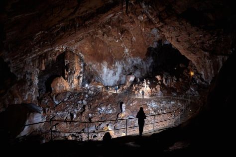
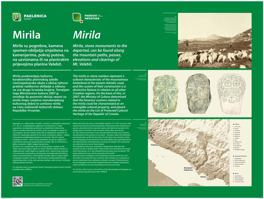
Mirila (Measures) are unique landmarks alongside the paths and trails of the Velebit Mountain. They were made in the period between the 17th and the 20th century, and are associated with a sepulchral custom of the local population who had to carry their dead to the cemetery because the church and the cemetery were far away. They consist of a headstone and a footstone, with paving between them. The length of the deceased was measured and marked with two stone tablets, so the measure was made after the deceased was buried. They were worshipped and visited more than the grave, where “only the body lies, without the soul that remained at the measure”.
 

Mirila, stone monuments to the departed, can be found along the mountain paths, passes, elevations and clearings of the Velebit Mountain. They preserve the memories of persons who died on the mountain slopes and had to be carried to the village church and then to the cemetery where they were buried. Today, Mirila are protected as the Intangible Cultural Heritage of the Republic of Croatia.

Visit exhibition "Mirila-resting places of the souls"  in ethno house Marasović in Starigrad-Paklenica. This is the exhibition about the stone markers of a unique funeral cult, which convey the customs, way of life and creativity of an entire era, in a contemporary interpretation of scientist and artist (Siniša ReberskiKrešimir RončevićRadivoj SimonovićTomo VinšćakMirjana TrošeljPetar i Josip StrmečkiJosip Zanki).


mirila


Site Grabove doline

There is preserved location with Mirila on the locality Grabove doline inside the Paklenica NP. These monuments are connected to the nearby settlement. 

Poučna staza Mirila

PLOČA TIP 8Tabla Mirila NP Paklenica 120x90cm 1

For more information, you can visit the Mirila Virtual Museum


Image

Javna ustanova Nacionalni park Paklenica
Dr. Franje Tuđmana 14a
HR - 23244 Starigrad-Paklenica

Tel.: +385 (0) 23 369 155, 369 202 (Verwaltung)

       +385 (0) 23 369 452 (Camp "Nacionalni park")
       +385 (0) 23 369 803 (Eingang 1 Velika Paklenica)


E-mail:
np-paklenica@paklenica.hr
prezentacija@paklenica.hr (info)

OIB: 24913665146
IBAN: HR0824070001100579272, OTP banka

Image

IZJAVA O ZAŠTITI PRIVATNOSTI I SIGURNOSTI OSOBNIH PODATAKA